Case Study: Settlement, Simplified - Remote Monitoring in Reclaimed Paddocks
Project Overview
The Port of Brisbane’s Future Port Expansion involves the staged reclamation of more than 220 hectares of new port land using hydraulically placed dredged material within reclamation paddocks founded on highly compressible marine clays. Monitoring vertical movement throughout filling, consolidation, and surcharging is critical to confirming settlement performance meets design expectations before land is released for development.
The Challenge
Settlement behaviour across the reclamation paddocks needed to be understood with confidence, but traditional surveying was labour intensive, required frequent access to active construction zones with heavy machinery and unstable ground, and produced intermittent data prone to gaps. Settlement markers were regularly disturbed or damaged by construction equipment, compromising continuity and repeatability.
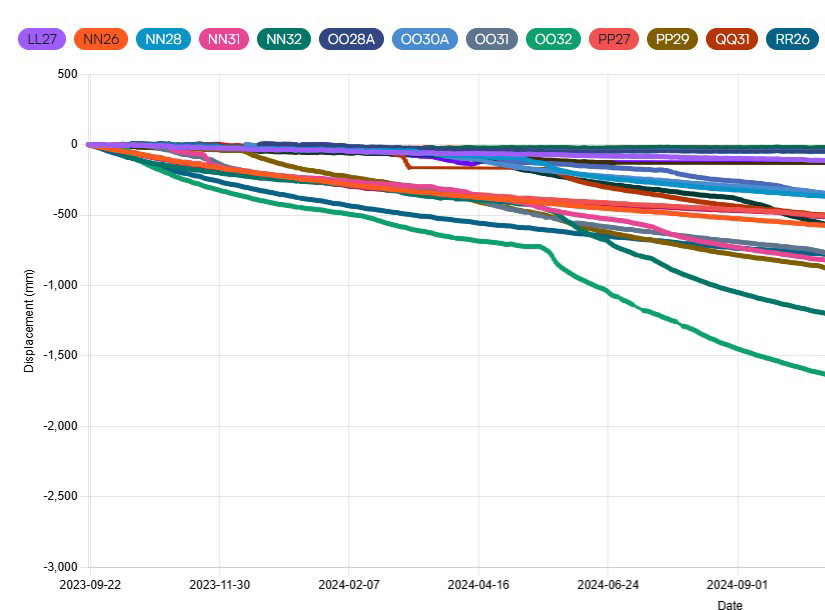
MGN Civil deployed 64 Kurloo-enabled settlement plates within a single paddock — each mounted on a galvanised pole — creating a dense monitoring network capable of capturing consolidation as it happened, without putting survey teams in the line of fire.
The Kurloo Solution
Kurloo was deployed across the reclamation paddocks to deliver automated, daily 3D settlement monitoring — reducing the need for frequent site access or intermittent survey campaigns.
- Automated daily 3D vector measurements tracking both vertical settlement and lateral displacement
- Accelerometer-based disturbance detection, flagging within ~15 minutes if settlement poles were struck or displaced
- Ultrasonic ground level sensor measuring fill height alongside 3D settlement rate, directly linking observed movement to loading history
- Continuous time series data replacing intermittent survey snapshots, significantly reducing data gaps
- Remote monitoring removing the need for surveyors to work near heavy plant on unstable ground
The Results
Automated monitoring delivered 5–10x increase in measurement frequency compared to traditional surveying.
Near real-time confirmation of consolidation after loading change, compared to weeks under traditional methods.
Accelerometers flagged if settlement poles were struck or displaced, enabling immediate QA/QC response.
Remote monitoring removed the need for survey crews to repeatedly enter active work areas on unstable ground.
Automated daily 3D vector measurements delivered high resolution insight into both vertical settlement and lateral displacement, reducing data gaps and improving confidence in consolidation trends.
“One of the key takeaways is settlement plate monitoring. We’re able to investigate and capture that data at higher frequencies than traditional surveying, at a fraction of the cost. This informs us about ground characteristics and future property development planning.”
Project Manager, Port of Brisbane
Operational & Construction Benefits
Kurloo enabled:
- Near real-time consolidation tracking, replacing isolated survey snapshots
- Improved assurance around ground performance and land release timing
- Reduced disruption to construction sequencing by removing survey crews from active work areas
- A defensible “ground truth” dataset suitable for long term reference and audit
Outcome
Kurloo is now an integral part of how settlement and consolidation are monitored across the Port of Brisbane’s reclaimed paddocks — delivering faster validation, reduced risk to personnel, and a reliable ground truth dataset supporting both immediate construction decisions and long term development planning.
Download the Full Technical Case Study
Access detailed deployment configuration, measurement methodology, and comparative performance data.